Sunday, June 1, 2014

Israel 2014 - Galilee; Day 5


The following descriptions in italics come from the webpage of Wayne Stiles, author of Walking in the Footsteps of Jesus. The photos are mine (Tim McKeown) from 2004.

COASTAL PLAIN/GALILEE – Start the day following the Mediterranean Sea we arrive at CAESAREA, the resort of Roman officials such as Pontius Pilate and prison of the Apostle Paul. 


Herod named the city, “Caesarea,” in honor of Caesar Augustus.
To further ingratiate the Roman ruler, Herod raised a temple for Augustus on the hill above the harbor. You can still see the ruins of the temple today. The site of the ancient harbor is today largely silted and covered with St. Augustine grass.
Herod’s Palace, Where Pilate Lived and Paul was Imprisoned
Herod chose to build his lavish palace in Caesarea on a natural promontory that juts out into the Mediterranean Sea.
  • The king had a freshwater swimming pool carved out of the natural bedrock at the end of his palace; the sprawling pool was almost Olympic in size.
  • Standing on this promontory today allows visitors to see where Herod’s pool once was and to imagine the luxury of Herod’s palace, which the Jewish historian Josephus called, “the most magnificent.”
After the death of Herod the Great in 4 BC, Caesarea became the Roman seat of power in Israel for 500 years. Roman governors, or procurators, resided in Herod’s opulent palace in Caesarea. The Apostle Paul was imprisoned on the grounds of the palace (or “Praetorium”) for two full years (Acts 23:35; 24:37). A sign today marks the likely spot.
The Pontius Pilate Inscription
When an team of Italian archaeologists excavated in Caesarea in 1961, they discovered an inscription with the words translated, “Pontius Pilate, Prefect of Judea.”
  • This archaeological find is the only written source outside of the New Testament that mentions the name, “Pontius Pilate”—the procurator who lived in Caesarea and who condemned Jesus of Nazareth to death.
  • A replica of the inscription stands in Caesarea today, and the original stands on display in the Israel Museum in Jerusalem.
In the Google Street view window below, the Pontius Pilate inscription stands in the foreground and Herod’s Palace is in the background. Use the buttons to explore and look around!
Our next stop is MEGIDDO to tour the ancient site and see the vast Jezreel valley with the name synonymous with Armageddon. 

Tel Megiddo’s tremendous value came from its strategic location as the sentinel of the most important pass through the Mt. Carmel range.

Whoever held Tel Megiddo in the ancient world controlled the traffic and trade along the International Highway to and from Egypt. That meant both military and financial security.

Taking Megiddo is like capturing a thousand cities. —Pharaoh Thutmose III
Its value simply can’t be exaggerated.
Tel Megiddo—Looking Back
Geography doesn’t change.
That’s why Tel Megiddo’s strategic location remained for centuries the envy of all who passed through the land of Israel.
When someone conquered the site, they often would rebuild directly on top of the rubble of the previous inhabitants. It’s no wonder today that Tel Megiddo’s towering ruins offer a stunning view of the Jezreel Valley.
After lunch, we to travel to NAZARETH, Jesus’ childhood home and visit Nazareth village, a recreation of life during the time of Jesus. 

The gospels tell us Nazareth rested on a hill with a formidable precipice (Luke 4:29). From here Jesus cold see the battles of Israel’s history.
The city’s name likely comes from the Hebrew term netzer, meaning “branch” or “shoot.” Some scholars believe this represents the faith of those Jews who returned from exile. Their hope focused on the coming Messiah, the “righteous Branch” of David, promised by the prophet Jeremiah (Jeremiah 23:5; 33:15).
But when He did finally show up, they tried to throw Him over the cliff.
Nazareth Today
Today, the residents of Nazareth represent very distinct people groups.
  • The older part the city includes communities of Christian and Muslim Palestinians.
  • The newer section, called Nazareth Illit (meaning “Upper Nazareth,” as in elevation), serves as the Jewish district.
The modern city has swallowed the ancient one. Ancient ruins are virtually non-existent. 

We then travel to the 2,000 year-old city of TIBERIAS. Overnight at the Caesar Premier hotel situated beside the sea.

A night view of Tiberias, the city, along the sea of Tiberias or Galilee.
The most striking place in Galilee has to be the Sea that bears its name. And the most striking time to see the sea? Sunrise . . . for sure.
Sunrise on the Sea of Galilee flattens all objects into silhouettes and paints the sky a murky red. As the sun peeks over the eastern hills, it draws a line of light from the distant shore straight across the water to wherever you stand—and follows you like a spotlight.
The Sea of Galilee was—and still is—notorious for unexpected storms. A squall in March 1992 sent 10-foot-high waves crashing into downtown Tiberias, causing significant damage.
In the dark, early morning, sometime between 3 and 6 a.m., Jesus came to His disciples by “walking on the sea” (Matt. 14:25; Mark 6:48; John 6:19). But instead of expecting their miracle-working Lord, the dozen on board assumed Jesus was, of all things, a ghost!
A full moon sets just behind Mount Arbel,
perhaps the place where Jesus went to pray
as He sent the disciples on ahead (See Mark 6) 
He comforted them in reply, got in the boat and stilled the storm. Then Mark wrote what has always seemed an unusual line to me: “They were utterly astonished, for they had not gained any insight from the incident of the loaves, but their heart was hardened” (Mark 6:51-52). They hadn’t learned a thing. Consequently, they had no idea what to expect!
If we’re honest, I think we’ll see that we resemble these men. The unrealistic expectations they had, which Jesus revealed, we also store in abundance. We have our agenda for how best to “serve God.” All other events—especially storms—just get in the way.

Israel 2014 - Capernaum; Day 6

GALILEE -We begin the morning at the MOUNT OF BEATITUDES site of Jesus’ Sermon on the Mount. 


The following descriptions in italics come from the webpage of Wayne Stiles, author of Walking in the Footsteps of Jesus. The photos are mine (Tim McKeown) from 2004.

The picturesque view from the Mount of Beatitudes offers visitors more than simply a beautiful view. It offers a place to consider truth taught there by One who knew it.

The Mount of Beatitudes marks the traditional location of the Sermon on the Mount. At the top of the slope, once called Mount Eremos, a modern church towers over area. The building’s eight sides commemorate the eight “beatitudes” that began Jesus’ celebrated Sermon on the Mount (Matthew 5:3-10).

Tidy gardens descend to a small, covered, semicircular sitting area that overlooks the lake. It’s a great place to sit, read, pray—or just enjoy the view.
Then proceed to TABGHA (Peter’s Primacy) where Jesus met the disciples after His resurrection. 


Not many places in Galilee can genuinely claim to be the “'own of Jesus.” But every visitor who enters the ancient site of Capernaum passes a sign that makes that boast. And it’s right. To me, of all the Christian sites by the Sea of Galilee, this one tops the list.
"The New Testament records that after Jesus’ resurrection, He met Peter and some of the other apostles by the shore of the Sea of Galilee (John 21:1-23). Tradition identifies it as Tabgha—my favorite of all Christian sites around the lake.
"The site always greets me with a funny sign. It reads: “Holy place. No shorts.” And yet Peter fished half-naked here. Peter knew it well."
Then we visit CAPERNAUM, and the synagogue where Jesus preached. 
A stroll around the site reveals numerous archaeological treasures. Unquestionably, one of the greatest finds in Capernaum is the restored ancient synagogue.
  • Although the white marble ruins date later than the first century, they rest on top of the thick, black basalt foundation of the synagogue in the time of Jesus.
  • A number of historical and biblical events occurred in this synagogue. It’s mindboggling to walk in the space and imagine the conversations that occurred there, several of which Scripture records (Mark 1:21-27; John 6:35-59).
The site also preserves a first-century house, which most likely belonged to Peter.
We then see the JESUS BOAT, a 2,000 year old fishing boat and take our own BOAT RIDE on the sea of Galilee. 
The Sea of Galilee will give us a treasure one day,” one man told his brother. Turns out, he was right.


In 1986, Yuval and Moshe Lufan, two sons of a fisherman in Kibbutz Ginosar, were walking the shores of the Sea of Galilee.
The drought that year dropped the level of the lake lower than the men had seen in years. One brother noticed something odd protruding from the mud.
It was an ancient nail. As he poked around with his finger, he found another one. Then another. More digging unearthed pieces of ancient wood.
While they didn’t realize it at the moment, they had discovered a fishing boat that dated to the time of Jesus.

The Ancient Boat’s Excavation
The necessary permits obtained, archaeologists set to work excavating the vessel. The manner of construction revealed a boat typical of the first century.
Assembled with mortise-and-tenon joinery, the boat was built from oak as well as the resilient cedars of Lebanon—wood highly impervious to rot.
The construction, the nearby pottery, and three independent carbon 14 dating examinations revealed that the boat dates from 100 BC to AD 70. Apparently, the original owners of the boat salvaged what they needed before scuttling the boat beneath the waves.


A Race Against Time and Elements
Archaeologists dug a trench around the remains while keeping the wood moist by spraying it with water.  If the soft, spongy timbers dried out, they would disintegrate. After bracing the boat with fiberglass, excavators sprayed on polyurethane foam that hardened around each crevice of the craft. Once dry, the foam served to support the fragile vessel as well as allow it to float.
Archaeologists flooded the trench, and the boat floated on the Sea of Galilee for the first time in two thousand years.
The process of preserving the boat occurred over the course of several years. Scientists soaked a synthetic wax into the pores of the planks. The wax stopped any further deterioration that would occur as the wood contacted the air.
A Museum for the Boat
Visitors can see this amazing find today in a state-of-the-art museum named in honor of the late Yigal Allon—a minister for Israel’s government, a Palmach officer, and a founding member of Kibbutz Ginosar.
The museum tells the story of the boat’s discovery through a video presentation, photos and descriptions, as well as a scale model of how the boat would have appeared in its prime.
We journey on to the GOLAN HEIGHTS to see the archaeological site of TEL DAN with a gate from Abraham’s time. 
Several peaks in northern Israel elevate the experience of all who see them. Exalted in beauty as well as in altitude, they offer panoramas both unique and enlightening.

The high ground in history has always proven the most sought-for, whether people have used the hills for worship or simply for military advantage.

Several summits in the Golan Heights offer beautiful panoramas and echoes of events in history that have proven significant—both in ancient and modern Israel.
Mount Hermon and Jesus’ High Point
 
Of all the peaks in the Golan Heights the most famous is also the highest in elevation. On a clear day, the snowcapped peaks of Mount Hermon can be seen for miles. Its sheer beauty has inspired the worship of both the godly and the pagan, with more than 20 temples of antiquity in the area.
  • The highest peak in Israel—at almost 7300 feet—Hermon offers the country’s only snow ski resort.
  • Hermon also has an off-road cycling park, a cable car, numerous Druze villages with black coffee, and picturesque views year-round.
The Scriptures picture Hermon as a metaphor of majesty, blessing, and beauty (Psalm 89:12; 133:3; Song of Solomon 4:8). With Caesarea Philippi at its base, Mount Hermon is likely the “high mountain” on which Jesus experienced His Transfiguration (Matthew 16:13; 17:1).
Mount Bental and the Valley of Tears
Providing one of the most picturesque views in Israel, the dormant volcano of Mount Bental offers an unrestricted view of Mount Hermon, the surrounding Golan Heights, and the mountains of Southern Lebanon.
  • The strategic lookout proved its worth in the 1973 Yom Kippur war when a badly outnumbered Israeli army defeated the Syrian army in the one of the largest tank battles in history.
  • Because of the heavy losses the ground between Mount Bental and Mount Hermon became known as the “Valley of Tears.”
The visitors’ center atop Mount Bental offers an educational experience by means of an automated information system in the network of IDF bunkers and remaining trenches. Humorous scrap-iron sculptures bring a smile to visitors’ faces.
Quneitra Overlook and a Demilitarized Zone
The view from the vantage at the Quneitra Overlook allows visitors to see the border between Israel and Syria as well as a beautiful view of Mount Hermon.
  • At one time, Quneitra represented the largest Syrian city in the Golan and was home to the Syrian army. Since the Yom Kippur War of 1973, the border between Israel and Syria has remained relatively calm.
  • In the demilitarized zone between the two nations, visitors can clearly see the United Nations camp.
Standing at the Quneitra Overlook allows one to imagine the determination Saul of Tarsus maintained in order to arrest Christians in Damascus, forty miles to the north (Acts 22:5-6).

We also will visit the high place of Jeroboam and CAESAREA PHILIPPI (palace of Herod Philip and Temple of Pan). 

Read 1 Kings 12:26-30.

By providing alternative places of worship, Jeroboam appealed to the laziness of the human spirit. Worshipping at Tel Dan was far more luxurious than Jerusalem. And worshipping at Bethel was more convenient. Substituting the priests, the feast, the places—all were outside of God’s will.

The world, the flesh, and the devil will always tempt us with Jeroboam’s words: “It is too much for you to go up to Jerusalem!” Sin always provides a substitute more convenient and more attractive to our flesh.

Three simple examples:
  1. A closer church—but it doesn’t teach the Bible accurately.
  2. An attractive or clever spouse—who isn’t a Christian.
  3. A lucrative vocation—that requires moral compromise.
Our relationship with God must remain a matter of obedience before convenience. In the end, we find it far more satisfying.
In a land where water is life, it’s no wonder one of the major sources of water would become a primary place of worship.

Regrettably, the god worshipped at Banias was not the God of Israel.


What an absolutely beautiful area! The flowing streams and the nearby waterfalls offer some of the most pleasant and inviting surroundings for tours, holidays, and family outings.

But that’s not why Jesus came here.

The god Pan Worshipped at Banias

The melting snows at the peak of Mount Hermon seep into the ground and appear at its base. From the mouth of a large cave bubbles a cold, clear stream that helps to form the headwaters of the Jordan River. Josephus referred to the streams that flow here as the fountain of the Jordan.

Archaeology has uncovered an open-air shrine above the cave from which the water flows. Niches still visible in the side of the cliff held statues of the Greek god Pan—the mythical half man, half goat who played the panpipe.

We then go for a baptismal service at YARDENIT and return to the Caesar Premier beside the Sea of Galilee.

The Jordan River, in which John the Baptist baptized his cousin Jesus of Nazareth, is a river in Southwest Asia which flows into the Dead Sea. It is considered to be one of the world’s most sacred rivers.
 
It originates approximately 200 meters above sea level on the slopes of Mt. Hermon, Israel. It ends its course at the lowest spot in the world, the Dead Sea, at 420 meters below sea level. Along its course, the Jordan feeds two lakes: the Hula (now almost completely drained) and the Sea of Galilee. In its course from the Sea of Galilee to the Dead Sea, the Jordan travels a winding 230 kilometers, covering just 105 kilometers in a straight line.

Numerous references to the Jordan River appear both in the Old Testament and the New Testament, indicating its biblical importance and
sanctity. In fact, the Jordan River is mentioned about 175 times in the Old Testament and about 15 times in the New Testament. The word Jordan comes from the Hebrew word ‘yarden’ meaning descender. This name is appropriate for the river that courses from the heights of Mt Hermon to the depths of the Dead Sea.
(Source: click here)

Israel 2014--Jordan Valley; Day 7

The following descriptions in italics come from the webpage of Wayne Stiles, author of Walking in the Footsteps of Jesus. The photos are mine (Tim McKeown) from 2004.

JORDAN VALLEY/JUDEAN DESERT- 

We start the day at the south end of the Galilee area at BETH-SHEAN, one of the largest archaeological sites in Israel with Egyptian, Philistine, and Roman remains. 


Because the spot was so good, every nation wanted control of Beth Shean. And whoever held it always seemed to contend with those who would wrench it from their grasp.
Perhaps its strategic location gave Beth Shean its name, “House of Security.”
But security only works when you trust in God.
Beth Shean’s Prime Spot
As with most ancient sites in the Holy Land, geography explains the reasons for Beth Shean’s significance.
  • For thousands of years, Beth Shean stood as Canaan’s front door to all westbound traffic from the Jordan Valley to the strategic Jezreel Valley and the Mediterranean Sea. Its surroundings are fertile with abundant water.
  • Egypt dominated the land of Canaan just prior to the Exodus (1446 BC), and Beth Shean served as the primary city of the region.
What God’s People Abandoned, Others Controlled
In ancient Israel, Joshua allotted the city to the tribe of Manasseh (Joshua 17:11). But Manasseh failed to drive out the Canaanites who lived there, and half of Manasseh settled across the Jordan Valley in what is modern Jordan (Judges 1:27).
  • During the reign of King Saul, the Philistines controlled Beth Shean. In fact, after Saul’s tragic death on nearby Mount Gilboa, the Philistines fastened the decapitated bodies of Saul and his sons to the wall of Beth Shean in the open square (1 Samuel 31:10-12; 2 Samuel 21:12).
  • The city remained a thorn in the side of Israel until the time of David and Solomon (Judges 2:3; 1 Kings 4:12).
  • After Alexander the Great swept across the Middle East, Beth Shean was renamed Scythopolis (“City of the Scythians”) and became a prosperous Greek city.
  • Once Rome gained control of Israel in the first century BC, Scythopolis became one of the cities of the Decapolis, the only one of the “ten cities” west side of the Jordan River.
  • During the Byzantine era, Scythopolis served as a major center for Christianity.

An earthquake in AD 749 toppled many of the city’s great structures and put the death blow to its prosperity. At the base of the tell today, columns still lay on their sides where they fell.
We then drive to JERICHO where the walls collapsed for the army of Israel under Joshua. 


On the monochrome landscape north of the Dead Sea, a conspicuous green splotch appears at the western edge of the Jordan Rift Valley.
“The city of palm trees” exemplifies what we imagine when we picture an oasis.
Jericho’s date palm trees have roots that stretch toward a source of fresh water that has turned a desert into a garden. Visitors to Jericho, or Tell es-Sultan, can see the perennial spring that supported the city for centuries and provided a splendid irrigation system, distributing water to the plain as well as to all travelers in antiquity. Likely, Prophet Elisha purified this spring (2 Kings 2:21).
The “oldest city on earth” also sits as the lowest one—at more than 800 feet below sea level. Jericho owes its existence to the spring, to be sure. But the city also sits at the base of the primary roads that ascended from the Jordan Rift valley up to the Hill Country of Judea. Anyone crossing the Jordan River from the Plains of Moab had Jericho to face.
The walled city stood as a strategic roadblock that no one passing could ignore.
Enter Joshua.
Joshua and Jericho—the Battle Continues Today
The favorite Bible story of many children remains Jericho’s most renowned event—the day its walls came tumbling down (Joshua 6). When Joshua and the nation of Israel crossed the Jordan Riverfrom the east, only Jericho stood between them and the Promised Land.
The archaeologist’s spade has excavated Jericho more than any other site in Israel—except Jerusalem. The tell sits as a 10-acre mound, about as big as two city blocks, with more than 26 separate layers of occupation beneath its topsoil.
  • In 1868 Charles Warren excavated Tell es-Sultan but concluded the tell offered little to consider.
  • Other archaeologists continued to dig, including Sellin and Watzinger from 1907-1913, Garstang from 1930-1936, and Kenyon from 1952-1958—to name a few examples.
  • During her excavation, Kathleen Kenyon discovered a Neolithic tower 26-feet in diameter and 26 feet high, which she dated to 8000-7000 BC. The purpose for this tower still bewilders most archaeologists. This discovery and its alleged date offer the basis for Jericho’s fantastic boast as being “the oldest city on earth.”
  • Most recently, Italian archaeologists have done significant work at the tell, finding remains from the Early and Middle Bronze periods.
We drive southwest of Jerusalem to QUMRAN, site of the community that produced the Dead Sea Scrolls and of Dr. Price’s excavations on the southern plateau.


In 2004, Dr. Randall Price and Oren Gutfeld of the Hebrew University of Jerusalem led a team which excavated an intact, sealed, jar, discovered at Qumran, the site where the Dead Sea Scrolls were found in nearby caves. It was found about 50 meters south of Qumran in an uninhabited area that may have been used for agriculture. Animal bones and pottery shards were unearthed nearby. 

A multinational team of scientists have been analyzing the jar and their findings published in the journal Archaeometry. “The finding of an intact and sealed storage jar is an extremely rare event,” the researchers stated. The discovery “provides a unique possibility to analyze its last contents.”

Altogether nine scientists are credited in the paper. Kaare Lund Rasmussen, of the University of Southern Denmark, is listed at the lead author.

We then proceed to EIN BOQEK by the southern end of the Dead Sea to check-in to the beautiful Isrotel Hotel (the better one).

Israel 2014 -- Ein Gedi; Day 8

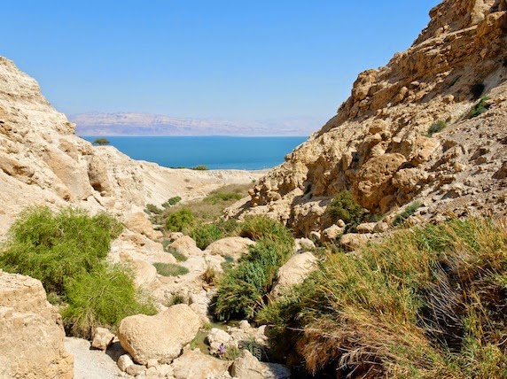
JUDEAN DESERT- Begin the morning at EIN-GEDI where David hid from Saul and composed some of the Psalms. 
(Source: shalomisraeltours.com)

Ancient travelers who made their way along the shores of the Dead Sea would no doubt shake their heads when they saw it.

How could so much water stand in such a barren place—and none of it be drinkable?

Before the obliteration of Sodom and Gomorrah, the Jordan Valley looked like the “garden of the Lord” (Genesis 13:10). But afterwards, even the many springs that bubbled beside the Dead Sea tasted too salty to swallow. The plentiful waters gave nothing in the way of sustenance.

They only offered a spiritual prompt of the need to take God seriously.
Against this depressing backdrop of death and desperation flows the Ein Gedi.

Ein Gedi—A Spring for More than Goats

If you want to find where history took place, just look for the waterholes.

Ein Gedi means, “Spring of the Wild Goat,” and suggests that animals—not just people—depended upon its fresh and plentiful streams (1 Samuel 24:1-2).
  • Because Ein Gedi represented one of only two springs that offered fresh water west of the Dead Sea, every nomad, wanderer, and warrior stopped there as they passed.
  • The Bible records Ammonites, Edomites, Meunites, and Moabites—Judah’s neighbors east of the Jordan—gathering there before their attack on Jehoshaphat (2 Chronicles 20:1-2).
But Ein Gedi served as more than a popular pit stop for travelers.
With regional water so scant, the spring hosted numerous settlements throughout history—thousands of years of continuous habitation.

  • God allotted Ein Gedi to the tribe of Judah (Joshua 15:62), from which came David.
  • David’s familiarity with the oasis and its caves allowed him to select hiding places from the jealous King Saul (1 Samuel 23-24). David may have written Psalms 57 and 142 here, as the superscription for each psalm mentions David composing them in a cave.
  • The Hasmoneans made Ein Gedi their royal estate and administrative center in the 2nd-century BC.
  • Eusebius described Ein Gedi in his Onomasticon as being “a very large village of Jews.”
  • The area has a Canaanite temple as well as Roman forts, a Byzantine fort, and an Israelite fort—all situated to protect the nearby roadway.

Next we drive to MASADA, site of the Jew’s final stand against the Romans in AD 73, ascending by cable cars to see the remains of Herod’s palatial fortress and visit the Masada Museum.  

source: routestravel.com

Towering 1300 feet above the Dead Sea, Masada looks as intimidating today as it did to those who stood at its base thousands of years ago. This natural mesa looms tall across from the Lisan at the southern half of the Dead Sea.

Steep cliffs on all sides make the mountain look virtually impregnable. And it was.

Getting to the top has always come at a price. For modern visitors, that price amounts to a cable car ticket. But in antiquity, the price was a hard hike up the steep path Josephus labeled the “snake.”

In 1867, explorers rediscovered this pathway that lies along the eastern edge of Masada. For most folks, climbing the “Snake Path’’—the serpentine trail that snakes back and forth up the mountain—takes almost an hour. Going down is another story. I can testify that a person with a good set of shoes can run down the snake path in 12 minutes (especially if your group is about to leave you).

Masada Means “Stronghold”
After Rome made Herod the Great king, he came to the mesa in AD 37 to fortify it, erecting an eighteen-foot high wall around its perimeter.
  • His made winter palace there, and as was true with all of Herod’s fortresses, had every comfort and convenience he could manage.
  • The palace clung to the northern cliffs of Masada like a barnacle.
  • Covered staircases gave access to three levels of terraces and portions of his beautiful mosaics are still visible.
The Final Stand against Rome
After Rome destroyed Jerusalem’s temple in AD 70, a number of Jewish patriots took refuge in Masada.
  • Led by Eliezar Ben Yair, they stood firm against Rome for several years.
  • According to Josephus, on April 15, AD 73, the Romans crested the summit to discover that almost 1000 patriots had chosen to take their own lives rather than surrender their lives and families to the cruelty of Rome (Wars 7:394-397).
  • The western side of the mesa still shows the spine of Rome’s siege ramp—an earthen incline constructed to breach the defenses of the Jewish fortress.
Some historians give serious doubt to Josephus’ fantastic account, even though it offers our only history of the patriots’ demise. His story represents what we would want to believe occurred, whether it did or not.

Masada remains a symbol of Israel’s resolve even today. Many Israeli soldiers have stood atop the mountain and uttered the oath: “Masada shall not fall again.”


We then return early afternoon to the Isrotel Hotel for leisure time to enjoy the amenities of the hotel’s spa (optional), the immense swimming pool or experience floating in the DEAD SEA at the hotel’s private beach and a delicious evening buffet.